Unprecedented rainfall patterns linked to climate change are leading to catastrophic floods, revealing vulnerabilities in infrastructure and preparation.
Severe Rainfall Events Rise as Climate Change Takes Toll

Severe Rainfall Events Rise as Climate Change Takes Toll
New data indicates that increasing extreme rainfall events pose a growing threat, particularly in regions like Texas known for severe weather.
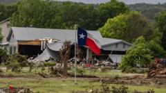
As climate change continues to warm the planet, extreme rainfall incidents are becoming alarmingly more frequent and severe, especially in flood-prone areas such as Central Texas. The rising global temperatures facilitate an increase in moisture content in the air, which fuels storms capable of delivering extraordinary downpours. This perilous combination of natural factors, outdated infrastructure, and inadequate early warning systems has led to devastating floods like those recently experienced in Texas.
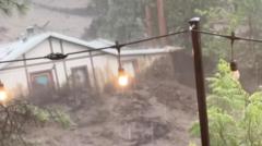
In the Hill Country of Texas, an area often referred to as “flash flood alley” due to its propensity for sudden inundations, meteorological conditions have reached alarming levels. The confluence of humid air streaming from both the Gulf of Mexico and the tropical Pacific Ocean sets the stage for severe storms when it encounters cooler air from the Great Plains. The unique topography of the region allows heavy rainfall to be rushed into river valleys, thereby transforming once-gentle streams into torrential floods.
Recent data illustrated the stark severity of the situation: within a six-hour period, a band of rain hit the region with probabilities of less than one-tenth of one percent occurring any given year. The Guadalupe River experienced an astounding rise, surging from three feet to 34 feet in just 90 minutes—a testament to the extraordinary volume of water that overwhelmed the area. In one instance, river flow jumped from 95 cubic feet per second to an unbelievable 166,000 cubic feet per second.
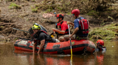
As the impacts of climate change become more pronounced, proactive measures are necessary to adapt to and mitigate future catastrophic weather events, highlighting the urgent need to modernize infrastructure and enhance monitoring and warning systems to protect communities.
In the Hill Country of Texas, an area often referred to as “flash flood alley” due to its propensity for sudden inundations, meteorological conditions have reached alarming levels. The confluence of humid air streaming from both the Gulf of Mexico and the tropical Pacific Ocean sets the stage for severe storms when it encounters cooler air from the Great Plains. The unique topography of the region allows heavy rainfall to be rushed into river valleys, thereby transforming once-gentle streams into torrential floods.
Recent data illustrated the stark severity of the situation: within a six-hour period, a band of rain hit the region with probabilities of less than one-tenth of one percent occurring any given year. The Guadalupe River experienced an astounding rise, surging from three feet to 34 feet in just 90 minutes—a testament to the extraordinary volume of water that overwhelmed the area. In one instance, river flow jumped from 95 cubic feet per second to an unbelievable 166,000 cubic feet per second.
As the impacts of climate change become more pronounced, proactive measures are necessary to adapt to and mitigate future catastrophic weather events, highlighting the urgent need to modernize infrastructure and enhance monitoring and warning systems to protect communities.