The Department of Defense has agreed to keep vital satellite data available for hurricane forecasting through July 31, despite initial plans to cut access, enabling meteorologists to maintain accurate predictions during peak hurricane season.
**Temporary Extension Granted for Crucial Satellite Data in Hurricane Forecasting**

**Temporary Extension Granted for Crucial Satellite Data in Hurricane Forecasting**
U.S. officials extend access to essential satellite data for hurricane monitoring by one month amid cybersecurity concerns.
The Department of Defense (DoD) announced a brief reprieve on the availability of satellite data critical for tracking hurricanes, extending access until July 31, after an earlier announcement indicated data would be cut off by June 30. This decision came following concerns about a “significant cybersecurity risk” and was influenced by a request from a NASA scientist.
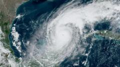
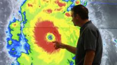
Meteorologists and climate experts expressed alarm at the potential disruption caused by the original decision, which could severely hinder hurricane forecasts and jeopardize safety measures across affected areas. The National Oceanic and Atmospheric Administration (NOAA) previously cited “recent service changes” when revealing that the satellite data, which comes from three satellites co-operated with the DoD, would soon be unavailable.
Michael Lowry, a hurricane expert with experience at both the National Hurricane Center and FEMA, indicated that the extension was largely reactive, revealing a lack of awareness among government forecasters regarding the DoD’s intentions. However, the extension is still not sufficient to cover the peak hurricane months of August through October, when the risk of intense storms and rapid intensification is notably higher.
Furthermore, the halted data services impact not just hurricane predictions but also ongoing climate research. Researchers studying sea ice dynamics in polar regions rely on this data to observe changes critical for understanding global climate trends. Dr. Sharon Stammerjohn, a senior research associate at the University of Colorado, emphasized that the absence of satellite data, particularly from remote regions like Antarctica, could lead to significant knowledge gaps in the study of climate change's effects.
While alternative satellite data from other agencies like the European Space Agency may exist, discrepancies in data calibration and resolution present challenges for researchers attempting to fill the void. Without the comprehensive records provided by the current satellites, the scientific community may struggle to track vital climate variables effectively.