In brief
Bolstering the flood threat in Nepal has dire implications for India’s low‑lying plains. Himalayan rivers splay over shared borders, carrying not just water but vast volumes of sediment that can overwhelm embankments and dam structures. Experts warn that the danger is not limited to the Kosi; the Ganges basin, the Ghaghara and Bihars rivers risk disaster during heavy monsoon rains and unexpected mountain debris flows. While hydrological data flows between the two countries, gaps in real‑time monitoring, shared forecasting models and last‑mile communication leave India exposed. The new floods underscore a larger Himalayan hazard system whose size is growing under climate change.
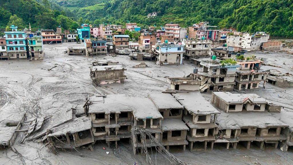
Floods that devastate Nepal’s border region are a warning not just for that country but for India’s plains downstream. It is not simply water flowing from south to north; it is a complex chain of rainfall, sediment, and river‑bank dynamics that can overload any embankment or watershed management plan.
The death toll has crossed 1,000 in Nepal since the 2026 floods hit the Tibet border.
Shared Rivers and “Water Bugs”
Three major Himalayan rivers – Kosi, Gandak, and Karnali (Ghaghara) – run from Nepal into India. Smaller streams like Bagmati and Kamala also rush from the Siwalik foothills into the plains. Each flood that drains into India is shaped by:
- Precipitation in Nepal: monsoon showers over steep, thin catchments.
- River behaviour: sediment loss at the mountain front, braided channels on the plains.
- Indian conditions upon arrival: river‑bed fullness, embankment integrity, local drainage.
India’s Most Vulnerable States
Bihar remains the worst hit: three‑quarters of northern Bihar is flood‑prone. The Kosi is dubbed the “sorrow of Bihar.” Uttar Prachod, Uttarakhand, and North Bengal also face risks from the Ghaghara, Rapti, and secondary tributaries. While Bihar dominates in scale, the adjacent territories are equally at risk, according to hydrologist Pradeep Man Dangol.
Timing and Degenerating Infrastructure
Experts say a 12‑hour to two‑day window can be gained for ordinary monsoon floods, but flood severity depends on local conditions. The 2008 Kosi disaster – “structural not hydrological” – showed how inadequately maintained embankments can fail under ordinary river flow. In 2026, a Rasuwa debris‑flow sent a surge to Triveni in under eight hours, illustrating how fast hazards can arrive.
Real‑Time Data – Still an Incomplete Picture
India and Nepal share rainfall and river‑level stats via joint networks. Yet gaps remain: few real‑time stations in Chure catchments, no common forecasting model, and limited data on embankments, sediment loads, and channel geometry. A warning that reaches a district office is not the same as a household receiving alarm.
Misconception: “Water Release” vs. “Natural Flow”
Many assume Nepal releases floodwaters intentionally. In reality, Nepal’s largest reservoir – Kulekhani – holds less than a tenth of a cubic kilometre; it cannot release large volumes. The Kosi and Gandak barrages are owned by India. When Nepal floods, it is essentially rain pouring down, not a gate opening. However, Nepal provides up to 40% of the Ganges’ annual flow, making the Himalaya a critical hydrological hub.
The Real Concern – Himalayan Hazard System
The latest Nepal floods mirror disasters in Chamoli and Dharali, where glacial collapse or sudden debris releases turned ordinary floods into high‑energy currents. Climate change intensifies rainfall bursts and accelerates permafrost thaw, meaning debris flows and glacial lake outbursts are becoming more frequent. Each event not only floods the plains but also raises riverbeds, diminishing channel capacity across the border.
Bottom Line for India
India should not merely worry about the Kosi but the entire Himalayan network. Shared data, better forecasting, consistent river‑bank maintenance, and a coordinated early‑warning system are essential. The key is recognising that the risk arises from the combined behaviour of mountains and plains – an upper‑downstream‑down‑stream relationship that cannot be reduced to blame or blame, but to shared responsibility and proactive adaptation.