Tornadoes, thunderstorms, and blizzard conditions are forecast to pummel parts of the eastern US. More than 34 million people were under tornado watches from Florida to New Jersey. The National Weather Service (NWS) reported that nearly 3ft (0.9m) of snow have fallen in Minnesota, Wisconsin, and northern Michigan since the storm began this weekend.
The bulk of the storm is expected to churn off the east coast into the Atlantic by Tuesday, with abnormally cold weather to follow in its wake. Over 11 million people are under blizzard warnings, and another four million are under winter storm warnings.
By Monday evening, nearly 4,600 flights had been cancelled and almost 11,300 delayed, with the bulk of cancellations occurring at Chicago's O'Hare International Airport and LaGuardia in New York.
More than 406,000 customers were without power, a third of them in Michigan, followed by Virginia and North Carolina. In Minnesota, over 25in (63.5cm) of snow fell in parts of the state by Monday morning, with whiteout conditions forecast to make travel treacherous.
Severe thunderstorms are expected in parts of North Carolina, South Carolina, and West Virginia, while tornado warnings have also been issued for areas in northern Virginia and the Florida panhandle. Schools in parts of North Carolina, Wisconsin, and Minnesota were closed on Monday due to the adverse weather.
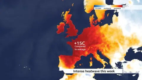
Additionally, Canadians in central Ontario and southwestern Quebec are facing severe weather with predictions of up to 20in of snow and strong winds. Meanwhile, the west coast is bracing for extreme heat as temperatures in parts of southern California, Arizona, and Nevada are expected to reach up to 109F (42C).
With its widespread impacts, forecasters say this could be one of the most significant weather events to hit the US this year, potentially affecting roughly 200 million people across various states.